A Trip to Arches and Canyonlands National Parks in Southeast Utah
♦ Routes (free): Detailed travel itineraries in USA
Routes: Detailed Travel Itineraries in the United States (Free)
General
Southeast Utah is a region of wild and magical nature, where the erosion of red rocks by the forces of nature created hundreds of amazing canyons, arches, bridges, spires, pillars, and giant natural sculptures scattered over vast areas. The area features several impressive national and state parks where it is highly recommended to visit and admire nature's wonderful works of art. The most impressive parks in the area are Arches National Park and Canyonlands National Park, both located near the town of Moab.

This area is also a paradise for adventure sports enthusiasts: off-roading, river rafting, mountain biking, horseback riding, and more. South of these parks lies the much smaller Natural Bridges National Monument, which features three natural bridges accessible via hiking trails, and Monument Valley, where giant monoliths of various shapes rise from the desert floor, which with a little imagination resemble an elephant, a camel, mittens, and other creatures. This park is located partly in Utah and partly in Arizona.
♦ Recommended Hotels for Travelers in Arches and Canyonlands Parks:
It is recommended to stay in the town of Moab, Utah, which is adjacent to these parks:
Fairfield Inn & Suites by Marriott Moab
A hotel with studio rooms, breakfast included, small fridge, microwave, pool, free internet, and parking. Fitness center.
Or:
Sorrel River Ranch Resort & Spa
A 4-star hotel, rooms and suites for 2-6 guests and also a villa for 12 guests. Kitchenette, dining area, seasonal pool, jacuzzi, gym, free internet, and parking.
Or:
A hotel with rooms for 2-6 guests, seasonal pool, jacuzzi, small fridge, microwave, gym, free internet, and parking.
Or:
Best Western PLUS Greenwell Inn
Rooms for 2-4 guests, seasonal pool, fitness center, microwave, free internet, and parking.
Nearby is the only meeting point in the US where the borders of four states meet: Utah, Arizona, Colorado, and New Mexico. This interesting point is called "Four Corners". While traveling between the parks I mentioned, you will encounter rocks in interesting shapes and other unique natural phenomena, each of which has been given a name, for example: "Mexican Hat" and "Goosenecks".
"Mexican Hat"

The most convenient and recommended way to travel in southern Utah is, of course, in a rented car. Almost every road is a beautiful scenic drive. Public transportation in the area is very limited and it is advisable not to rely on it.
The first inhabitants who lived in the area were Native Americans, as early as 12,000 years ago. Mormons arrived in the area in 1847. To this day, it remains a wild area that is almost uninhabited.
Many Westerns were filmed in southern Utah, as well as many commercials, all thanks to the perfect natural setting. Among the famous films: Indiana Jones and the Last Crusade and Thelma & Louise. Moab is a small town with only 4,500 residents that serves as a recommended starting point for trips in the area. Many organized adventure tours also depart from there. The meaning of its name is: "The Great World". Moab is located about four hours drive from Salt Lake City, where the nearest large international airport is located.
Booking tours from Moab via GetYourGuide:
Recommended Travel Itineraries Combined with Utah's Parks
Below are sample itineraries; there are many other wonderful and diverse options, depending on the season, duration of the trip, and personal preferences.
Travel Itinerary in Utah's Parks with Parks in Arizona and Colorado
Special and recommended national parks that integrate well with a trip to Arches and Canyonlands parks in southeast Utah (with links to my articles about them) are: Capitol Reef (two and a half hours drive west of Moab), Petrified Forest located in northeast Arizona, and
Mesa Verde National Park located in southwest Colorado.
You can also combine the itinerary described below with the classic travel route between the more famous and visited nature parks: The Grand Canyon,
Lake Powell, Bryce Canyon, and Zion Park, ending in Las Vegas. A detailed itinerary of such a trip is provided in the article: Travel Itinerary from Las Vegas to Grand Canyon, Lake Powell, Bryce, and Zion
Travel Itinerary from the Arizona-Utah Border towards Moab:
A travel itinerary starting at Four Corners and ending in Moab and Arches and Canyonlands parks, including Monument Valley, Goosenecks Park, and Natural Bridges National Monument.
Travel Itinerary Description
The start of the itinerary is at a unique corner in the US, "Four Corners," at the meeting point of four states: Utah, Colorado, Arizona, and New Mexico. This meeting point is located in a desert area in a Navajo Native American reservation. There is an entrance fee. The site has an exact marking of the meeting point, flags of the four states, a small visitor center, and plenty of Native American souvenir stalls. The site is located 0.8 km from the intersection of Highways 160 and 41.
West of Four Corners, on the Arizona-Utah border near highway US 163, is a unique park that also belongs to the Navajo tribe called: Monument Valley. This is a desert area of 130 sq km from which magnificent and giant cliffs in various shapes rise. Each is named after the shape it resembles: Mitten, Camel Butte, Elephant Butte, Three Sisters, The Thumb, Totem Pole, etc. Near the visitor center, there is a good view of the cliffs and also a 27 km dirt road between them. The road is quite bumpy, but it is suitable for driving all types of vehicles. Along the way, there are 11 viewpoints with interesting names such as: "Artist's Point" and "North Window" from which you can see the giant rocks up close. A very impressive place where dozens of Westerns, TV series, and hundreds of commercials were filmed, considered the eighth wonder of the world. The most beautiful hours for a tour are early morning and twilight. Entry to the park is for a fee. It is recommended to take a jeep tour to areas deep in the park where private cars have no access (for an additional fee of about 15 dollars per person for a hour and a half tour) departing from the parking lot near the visitor center. The park has a campground and a restaurant.
"Monument Valley"

Driving north along highway US 163 leads to a park named Goosenecks (you have to deviate slightly from the main road onto road U316, but the slight extension of the road is very worthwhile). The park is so named because it has a particularly impressive view from a high cliff edge over the San Juan River, which winds between cliffs and creates sharp turns like a goose's neck. The river carved its winding path inside a 480-meter-deep canyon. It flows for almost 10 km while advancing south less than 2.5 km due to the sharp bends. The view is stunning. There is a picnic area and toilets, but no water. Entry to the park is free.
Typical view in Goosenecks Park

The park is located about 13 km north of a tiny town called "Mexican Hat," which has almost nothing (including no restaurants...) except a rock that looks like a Mexican wearing a sombrero.
Further north from there is a small park called: Natural Bridges National Monument, located near highway U95 and reached via road U275. The park has three bridges created over a slow process by the flow of three rivers. These are the three largest bridges out of the 10 that exist in the entire world. There are viewpoints for each and hiking trails to the bottom of the bridges. A 14.4 km loop road passes between the bridges. The bridges were given Native American names (of the Hopi tribe): Owachomo, meaning "rock mound," Sipapu, meaning "place of emergence" (this is the second largest natural bridge in the world), and Kachina, meaning "dancer".
The shortest and easiest trail of all is the trail reaching Owachomo bridge, which is 0.8 km long. This is also the trail with the most moderate incline of all. The other two trails leading to the bridges are almost 2 km long and are much steeper. There is also a circular trail that passes between all the bridges at the bottom of the canyon. The entire route is about 13 km long and is intended for experienced hikers.
The park also has ruins and remains of buildings of the Ancestral Puebloans (Anasazi) who lived in the area 2000 to 650 years ago. At the park entrance is a visitor center with a display of the park's geology, flora, and fauna, and a short film about the area is screened. There is no lodging in the park except for very basic and quite poor campgrounds. Also, there is no food, fuel, or other services of this kind in the park. The site was declared a park in 1908 and is the oldest national monument in Utah. The park is open year-round but it is recommended to visit between late April and October (it is hot in the summer but not oppressive). Near the site, there are almost no settlements. Truly the end of the world. The nearest town where you can stay is Blanding, located 68 km west of the park.
Further along the route, you drive to stay in the town of Moab and from there visit the most impressive parks, Arches and Canyonlands, detailed below.
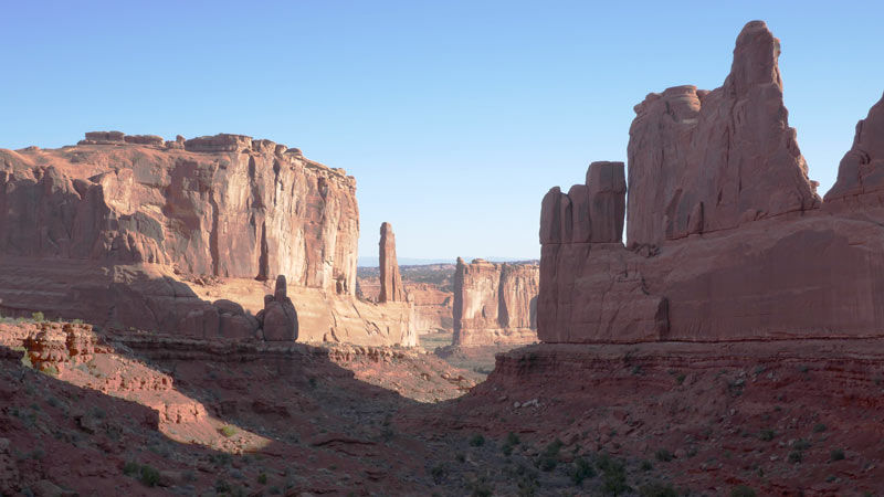
Arches National Park
One of the most special and interesting parks in the area. The park contains the largest number of natural arches in the world. Some of the arches were created in a slow erosion process that lasted millions of years. Most were created from red sandstone which, through slow processes by the forces of nature—water, ice, extreme temperatures, and underground salt movement—crumbled, eroded, and broke, leading to the formation of amazing arches but also natural sculptures, needles, cones, and other unique shapes in shades of red-brown-yellow. There are more than 2,000 natural arches in the park that can be seen from viewpoints and by hiking trails of all types and difficulty levels. The site was declared a national park in 1971 and covers 76,520 acres.
Park Location:
The nearest town to Arches is Moab. From it, you must drive 8 km north on highway 191 to the park entrance. Small airports are located both in Moab and in Grand Junction, Colorado, 190 km from the park.
The park is open year-round. The visitor center is located near the park entrance. The most recommended seasons to visit Arches are spring and autumn.
In the summer, it is very hot and temperatures can reach 43 degrees, while in winter the nights are very cold, with average temperatures in January being minus 8 degrees at night, while during the day it is 5 degrees. Blooming in the area peaks in April-May. Most visitors arrive at the park between March and October.
The park is relatively small, so it's enough to dedicate one day to see the best it has to offer.
There is one main road in the park, called: Arches Scenic Drive, which leads to the end of the park and branches off in two places and several roads for off-road vehicles. The park is divided into several areas with interesting names: "Courthouse Towers" in the south, "The Windows Section" in the center of the park, "Fiery Furnace" further on, and "Devils Garden" in the northern part. In "Devils Garden" is the highest concentration of named arches in the park.
Along the main road, there are many viewpoints of arches and other interesting landscapes.
One of the most famous and beautiful arches in the park is the "Delicate Arch" which, to see, you must turn right from the main road north of the "Windows area" and drive east about 3.5 km. This is a unique arch that looks like it was designed by an artist. You can reach the arch itself via a 4.8 km trail. Keep in mind that there is no shade at all along the trail.
It is also possible (and highly recommended) to view the arch from a more distant viewpoint called: Delicate Arch View Point, which is only about 90 meters from the parking lot.
Particularly Recommended Trips for Families:
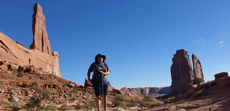
Park Avenue Trail
A recommended hiking trail that should not be missed is right at the entrance to the park and is called Park Avenue Trail because it has high vertical cliffs like skyscrapers; the view here is without arches but no less beautiful than the arches more characteristic of the park.
From the parking lot, you reach a high viewpoint into a canyon with high vertical walls. From the viewpoint, a trail descends into the canyon, about a mile long, and eventually reaches the main road so it can be done in one direction if the driver goes back to pick up the car at the end of the trail. A round trip takes about an hour.
Trip to Double Arch
Leads to it an easy hiking trail 1.2 km long. These are two large arches connected to each other, magnificent in their beauty, which can be climbed on, to sit at the opening of one of them and feel the power and greatness of nature compared to tiny human dimensions.
The width of the larger arch: 46 meters and its height 36 meters, while the smaller arch is 20 meters wide and about 28 meters high. The trail is located in the "Windows area".

Landscape Arch
A trip to the largest arch in the world called: "Landscape Arch" on a trail with a difficulty level of easy to moderate, 2.6 km long. The height of the arch is 34 meters and its width is almost 100 meters! Short side trails branch off the main trail leading to two additional arches: "Tunnel Arch" and "Pine Tree Arch". The trail is located in the north of the park in the "Devils Garden" area.
Sand Dune Arch Trail
A short and pleasant trail (only half a kilometer long) passing through reddish sands to a relatively small arch (dimensions 2.5X10 meters) hidden between large rock walls. Great for kids who will love rolling in the sand. The trail is located north of the "Fiery Furnace" area. You can continue on the trail another 600 meters to reach "Broken Arch".
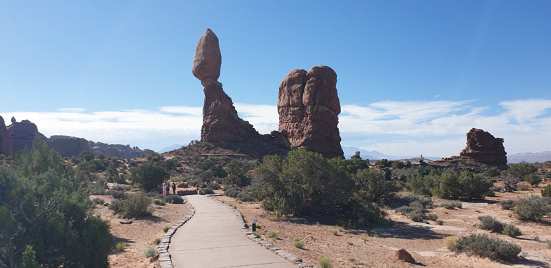
Balanced Rock
Another short trail is a 0.5 km circular route to "Balanced Rock," circling a large red rock standing on top of a tall cone.
Fiery Furnace Trail
Especially recommended is a guided tour by park rangers, which lasts about 3 hours in the "Fiery Furnace" area. This is a wonderful trip between high cliffs and needle-like rocks that create a magnificent maze where you cannot hike independently for fear of hikers getting lost among the rocks, spires, and arches. During the trip, you climb and descend among rocks in particularly narrow passages and meanwhile hear fascinating explanations from the ranger about the area's flora and fauna, nature phenomena, and geology, and discover hidden arches that cannot be seen from anywhere else. The tour has a modest fee. It is recommended to register for it a day or two before arriving at the park as it is very popular.

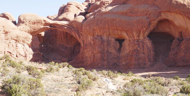
Cove of Caves
Giant caves and arches located near the road called Windows road.
Special Attractions in the Area:
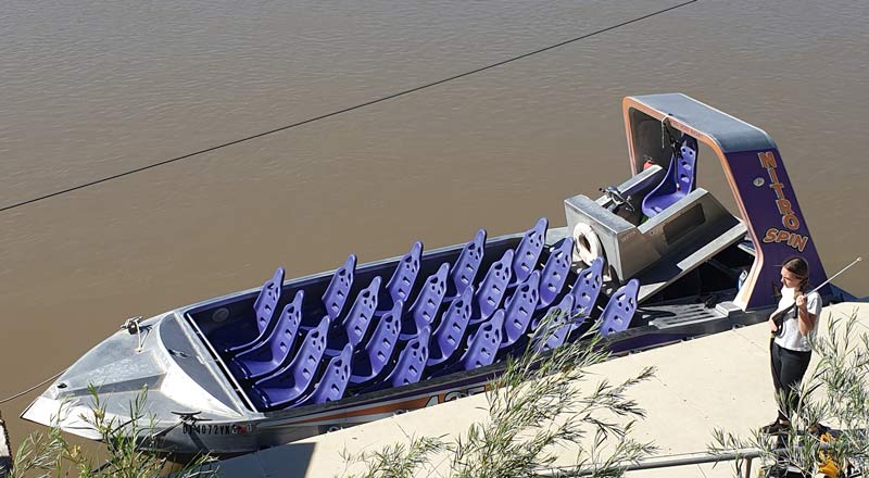
Experiential Speedboat Ride Near Arches Park
Near the town of Moab adjacent to Arches National Park, it is recommended to freshen up with a particularly wet ride in a speedboat on the Colorado River winding between high cliffs. The ride lasts about an hour.
The ride is accompanied by rhythmic music, traveling very fast with sharp maneuvers that create waves making all passengers in the boat get properly wet, especially those sitting in the front of the boat. Prepare spare clothes and shoes in advance!
Video of the speedboat ride:
Alternatively, those interested in a calmer ride in a river raft for 4 hours can book it here from the Viator site:
Colorado River Rafting: Afternoon Half-Day at Fisher Towers
Canyonlands National Park:
Not far from Arches lies a much larger national park named "Canyonlands". This park is divided into three parts that are completely separate from each other and each has its own separate entrance. Between the three parts of the park, the Colorado River and the Green River separate. Since there are no bridges over these rivers, you have to drive relatively long distances between parts of the park. Therefore, this park should be treated as three separate parks, each offering something different.
Visitor traffic in the park is significantly lower compared to famous parks like Bryce Canyon, Yosemite, or the Grand Canyon. The busiest period in the park when campgrounds in the area are full is during holiday weekends, Easter, and spring break, when the weather in the park is comfortable and pleasant. In summer, temperatures reach 38 degrees Celsius, which reduces the number of visitors, particularly those interested in hiking in the area. In winter, it is cold (due to the relatively high altitude of the park), though snow falls only rarely (due to low precipitation). Many of the roads intended for 4X4 vehicles are closed to traffic during the winter months.
The "Island in the Sky" area is the most visited area of Canyonlands. This is also the highest area in the park, with an average altitude of about 1,950 meters, overlooking both rivers. It offers magical views of deep canyons carved into the rocks by the rivers over millions of years (estimates speak of a process lasting 150 million years!). A 40 km road passes through the park with many viewpoints on the winding canyon walls. Along the way are also several interesting hiking trails of various difficulty levels. The road ends at the most impressive viewpoint of all: Grand View Point Overlook, from which the canyon is seen in all its glory and you can see the other part of the park, the "Needles" area. It is highly recommended to hike south on a wonderful 1.6 km trail passing near the canyon rim and reaching the canyon's edge. On the route, there is a place where the cliff drops steeply at once, and the hiker is there at a huge height with a primeval landscape stretching in every direction. The walk time each way is about 20-30 minutes. The entrance to this part of the park is located about 50 km southwest of the town of Moab and is considered the most accessible area of the park.
Another recommended hiking trail is: "Upheaval Dome" leading to a view of a large colorful crater, likely formed by a meteor strike. The crater's diameter is about 3.2 km and it is surrounded by tall rocks whose layers and strata have bent and twisted, creating a unique color combination. This is one of the most surprising and unusual places in Canyonlands.
It is worth stopping at another viewpoint called: THE GREEN RIVER OVERLOOK, which offers an impressive view of the "Green" River and the canyons created around it.
In the center of the park, near the park's main road, there is a short 0.5 km circular trail leading to a beautiful arch called MESA ARCH which frames part of the canyon view.
At the park entrance is a visitor center open from 8:00 to 18:00 in April-October and until 16:30 only during the rest of the year.
"Island in the Sky" in Canyonlands

"The Needles" area is located only 24 km south of "Island in the Sky," but you have to drive 220 km to reach it. This area is famous mainly for the many pillars and spires created there by erosion from reddish sandstone rocks. It has many other formations of natural sandstone sculptures, including arches, and also offers an impressive view of the canyon. The site also has ruins, petroglyphs (rock art), and remains of ancient Native American life. This area is located about 120 km southwest of Moab and about 70 km northwest of the town of Monticello. It is reached via highway US 191 and along the way, you pass near Newspaper Rock Park, which has hundreds of ancient Native American drawings on the rocks, some over two thousand years old. The drawings can be seen from the main road.
Here, too, there is a visitor center open from 8:00 to 17:00 from April to the end of October and until 16:30 during the rest of the year. A video called "Wild Rocks" is screened at the center.
In this part of the park is a campground called: SQUAW FLAT CAMPGROUND, operating on a first-come, first-served basis. The site is located in an area with a lovely view among large colorful rocks that many love to climb.
The park has an 11 km scenic road starting at the visitor center and ending at a viewpoint called: BIG SPRING CANYON OVERLOOK. Along the way are several viewpoints (less impressive than the "Island in the Sky" area, because the Needles area is lower), picnic areas, and hiking trails. Two dirt roads (intended for off-road vehicles) branch off the main road. One leads to "Elephant Hill," which offers a magical view of the canyon, and the other leads to "Cave Spring" area, where there is an easy one-kilometer circular hiking trail where you can see ancient drawings and an old cowboy camp. The "Needles" area has a wide variety of additional options for 4X4 off-road trips.
Another easy hiking trail is:
POTHOLE POINT TRAIL - 0.8 km long (about half an hour of leisurely walking) passing between many pits and holes in the sandstone where rainwater collects.
Most hiking trails in this area of the park are long and suitable for experienced hikers.
The "Maze District" is an area of 77 kilometers of a puzzle made of sandstone. The "puzzle" consists of a series of finger-like canyons whose tour is especially suitable for experienced hikers, adventure lovers, and challenge trips. The canyon trip is very confusing and requires navigation knowledge. This is the least visited area in Canyonlands, mainly because it is remote from any settlement and access is by 4X4 vehicles only. In this part of the park, there is no visitor center or services of any kind. A trip to this area also requires more time, and hikers arriving in the area usually dedicate at least three days to it. The nearest settlement is Green River, from which you drive west on I-70 and from there south on Highway 24 on a good dirt road for 74 km to a ranger station called Hans Flat.
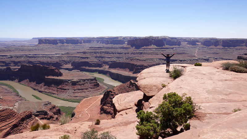
Adjacent to Canyonlands is a state park called: Dead Horse Point, which offers one of the most beautiful and impressive views in Utah and perhaps in the entire US: from several viewpoints in the park, you can overlook all the canyons and cliffs of Canyonlands National Park and its surroundings from horizon to horizon. The height of the viewpoints is about 1,950 meters above sea level, while about 650 meters lower, the Colorado River winds. The view from there is no less beautiful than the Grand Canyon's views because you see the cliffs from a closer distance and the colors are more vibrant.
The park is named so strangely because according to legend, horses left in a corral nearby went out through the corral door that was accidentally left open and reached the edge of the cliff overlooking the canyon. The horses died of thirst while watching the river flowing 650 meters below where they stood, unable to descend to it.
At the park entrance is a small visitor center with an interactive display. The park is open to visitors year-round from 6:00 to 22:00 and is located on road SR313, about 30 km from road 191, near Moab. The park has a small campground and organized toilets.
Additional articles about Utah: Bryce Canyon, Zion Park, Salt Lake City, Capitol Reef Park