A Trip Along the Eastern Coast of Taiwan
The eastern part of the island of Taiwan is characterized by a mountainous topography, and along the coast feature dramatic landscapes of cliffs dropping steeply into the sea. Most of the coastline is rocky and unsuitable for swimming.
The journey from Taitung to Hualien can be made either via scenic Highway No. 11 running right along the coast (a 3.25-hour drive) or via Highway No. 9 running through the long East Rift Valley (about 160 km long), flanked by high mountains on both sides (a 2.75-hour drive). This article describes the route along coastal Highway No. 11 from Taitung to Hualien.
♦ To book via Viator: A day tour in eastern Taiwan departing from Hualien:
Private Full Day Tour to East Coast and East Valley from Hualien

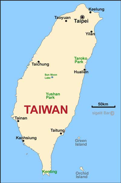
Map of Taiwan:
The City of Taitung
The city of Taitung is located on the eastern coast of Taiwan, about 120 km north of its southern tip. Numerous remains from the prehistoric settlement period were found in this city, which is why an ancient culture park and a prehistoric museum were established here, both of which are recommended to visit. The city is also known for its hot springs.
Hot Springs in Taitung
The hot springs are located in the Wenquan area, a suburb west of Taitung. This area features many hotels with hot springs.
The most successful and largest hotel of all is: Hotel Royal Chihpin, where staying is also warmly recommended.
The lobby at Hotel Royal Chihpin:

A 5-star hotel where guests enjoy free entry to the hot springs and the hotel's lovely pools. Note that part of the hotel's thermal pool area is nude-only. However, there is a nice area with pools at various temperatures and a variety of fragrances from flowers, fruits, and herbs.
The thermal pools at Hotel Royal Chihpin:

Very relaxing and especially pampering at the end of a nature-tripping day. The hotel features a selection of successful restaurants, including a Japanese Teppanyaki restaurant, and every evening the hotel hosts a dance and song performance by members of local aboriginal tribes dressed in traditional clothing.
Dance performance at Hotel Royal Chihpin:

Peinan Cultural Park
A large open-air park with walking trails and lawns, featuring a culture park with various exhibits and artifacts found in the area from the prehistoric settlement period, such as ancient stone coffins, tall stone pillars, reconstructions of ancient houses, and more.


Adjacent to the park, a prehistoric museum was established with exhibits found in the area.
Prehistoric Museum
A large 3-story museum with many exhibits and explanations also in English. Exhibitions cover the nature of the Taiwan region, human history and development, as well as the various tribes in Taiwan.


Chu Lu Ranch
Near Taitung in the mountains, in a idyllic location, is an agricultural ranch where visitors can feed rabbits, donkeys, cows, etc., with grass and carrots purchased on-site.

During the tour of the ranch, you can see various farm animals: horses, cows, donkeys, and rabbits. There is also a small train for children and large lawns.

The ranch also has a milk production and carton packaging factory.

There are many cow statues all over the ranch.

The site features a cafeteria overlooking magnificent scenery. The place offers a nice travel break that is especially great for the little ones in the group.

Xiaoyeliu Coastal Rock and Vegetation Geological Park
About a 15-minute drive north of Taitung along the coast brings you to the Xiaoyeliu Geological Park. A short trail leads from the site's parking lot to the shore, where large rocks in various shapes on the coast have earned names such as: Turtle Rocks, Big-Eyed Frog, Camel, Telephone, and more. Near the shore are various plant species characteristic of the location. The site also includes a souvenir shop, restrooms, and seating areas.


Donghe Township
Donghe Township is located about 20 km north of Taitung on the eastern coast of Taiwan. It is worth stopping here to see the channel where water appears to flow uphill and also to eat the popular stuffed buns (steamed buns) in this town.
Water Running Upward
In Donghe Township, located about 20 km north of Taitung on the eastern coast of Taiwan, there is a water channel about 30 cm wide that was used about 150 years ago by local tribes to irrigate their fields. Due to the topographical structure around the channel and the slope of the nearby road, an optical illusion is created where water flows uphill against the laws of nature. The site features souvenir shops, food, and fruit for tourists.

Bun Restaurants in Donghe Township
Donghe Township has several restaurants specializing in steamed buns in various flavors: onion, sweet bean, sweet sesame, brown sweet bun, bamboo shoot, pork, and more. Meatball soup is also available. Each bun costs 1 to 3 shekels. Highly recommended!

Bun restaurant in Donghe:

Sanxiantai Arch Bridge
The Arch Bridge is located about 60 km north of Taitung in eastern Taiwan. It is a picturesque bridge with eight arches that pedestrians walk up and down, leading to a small island near the shore. Around the bridge is beautiful scenery of cliffs, rocks, and the bay. On the small island itself, there is also a nice trail of several hundred meters. Don't miss the loop around the island, which abounds with vegetation and impressive viewpoints!

Jing Pu Tropic of Cancer Landmark
The Tropic of Cancer is latitude 23 degrees 26 minutes, which distinguishes between the tropical and subtropical zones on Earth. At this latitude, the sun reaches its zenith perpendicular to the Earth at noon on the longest day of the year in the Northern Hemisphere summer.
The site is located 73 km south of Hualien on the eastern coast of Taiwan. The site features two tall pillars indicating that the latitude line marking the Tropic of Cancer passes between them.

Shitiping Rock Observation
67 km south of Hualien is another geological site named Shitiping, where tremendous ocean waves have sculpted the surfaces of huge rocks on the shore into various shapes. The place is also called Stone Steps.

Tunnel and Cliff Suspension Walk - Qinbuzhizi Walk
A fascinating hiking trail can be found at a site called Qinbuzhizi Walk, located 44 km south of Hualien on the eastern coast of Taiwan. The site features a scenic hiking trail on a high cliff above an abyss with the sea below. At the beginning of the trail near the mouth of an abandoned tunnel, protective hard hats are provided for protection against falling rocks. At the end of the trail, you return through an abandoned tunnel that was once used by vehicles before the road was diverted to another route. Inside the tunnel, you will find a variety of vendor shops intended for tourists at the site.


Baqi Viewpoint
Taiwan's eastern coast highway is a scenic road paved across cliffs with dramatic views. At one of the curves of the road, about 35 km south of Hualien on the eastern coast of Taiwan, at a place called Baqi rest stop, there is a refreshment station offering a very beautiful view of the jagged and steep coastline.

Hualien County Stone Sculpture Museum and Park
In the city of Hualien, it is recommended to visit the Stone Sculpture Museum with a sculpture park surrounding it. The museum itself features an exhibition of delicate jade stone carving works, including explanations of the working method. The museum also hosts rotating exhibitions of artists' works. In the park surrounding the museum, many sculptures are displayed, mostly made of stone.


Short Video About a Trip to Eastern Taiwan:
Guided Tour in Taiwan to Book from Viator:
♦ 5-Day Trip to the Best Destinations in Taiwan -
-5Day Best of Taiwan: Sun Moon Lake, Tainan, Kaohsiung, Hualien