Travel to The Grand Canyon
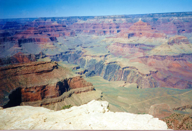
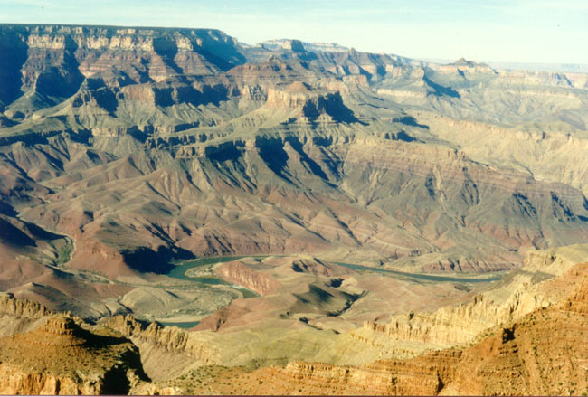
The grand Canyon is the most famous canyon in the word. The Colorado River, now winding through the bottom of the canyon, is what created this incredible geological wonder. The width of the canyon changes between 6.5 kilometres and 22 kilometres; its depth is 1600 metres measured from the southern rim and 1900(!) metres from the northern rim. The Northern rim is taller: 2680 metres above sea level compared to the 2100 metres of the southern rim. The canyon’s length is 443 kilometres but only a relatively small part of it can be seen from the national park’s viewing points. Regardless, The park is at the most breathtaking part of the canyon. Part of the uniqueness of the canyon stems from its colourful layers of rock, created over tens of millions of years and now exposed to the eyes of viewers from above. The Grand Canyon is a sort of natural museum for the history of the Earth.
Every year, the park gets over 5 million visitors! Expect crowding, traffic jams and parking problems in the summer months. The least busy months of the park are November to February, when the weather is cold and snowy.
The southern rim of the park is open to visitors all year round, 24 hours a day. The northern rim is closed to visitors from the end of October to mid May due to the weather conditions and snow-blocked roads. Most visitors to the park visit the southern rim. The northern rim has fewer facilities for tourists and is less accessible. However, since it is higher up, the view from the northern rim is even more impressive.
Park Location and transportation
The park is located
in northern Arizona. To get to the south rim of Grand
Canyon National Park you have a number of choices:
From Los Angeles and other locations in southern
California you should first take Interstate 15 north to
Barstow and then take Interstate 40 east from there to
Williams, Arizona. From Williams you should take Arizona
route 64 north to the Grand Canyon.
From Las Vegas
you should take U.S. route 93 southeast towards Hoover
Dam and Kingman, Arizona. From Kingman take Interstate
40 east to Williams, Arizona and from Williams take
Arizona route 64 north to the Grand Canyon.
From
Albuquerque and other eastern locations you should take
Interstate 40 west to Flagstaff, Arizona and then refer
to the directions from there.
From Phoenix take
Interstate 17 north to Flagstaff, Arizona and then refer
to the direction from there. From Flagstaff, Arizona
there are two possible choices for getting to the
Canyon: U.S. route 180 north to Arizona route 64 north
to Grand Canyon (south entrance) and U.S. route 89 north
to Arizona route 64 west to Desert View (east entrance).
Despite the relatively small distance between the two
rims of the canyon, it takes roughly four and a half
hours to get from one to the other as the route between
them is very indirect and therefore 340km long. The
northern rim is 70km south of Jacob Lake, Arizona and
you can reach it via Arizona route 67.
Airports in the area
The main airports closest to the park are Las Vegas airport (over 6 hours of driving away) and Phoenix airport (4.5 hours’ drive away). However, you can also fly all the way to Flagstaff on a smaller plane. The canyon itself even has a small airport, located south of the park, which gets its traffic from Phoenix and Las Vegas in the form of 10-seater airplanes.
Transportation Inside the park
Inside the park there is free transportation between its main facilities and viewpoints. The services run from mid-March to mid-October. There are two transport lines: the West Rim Loop and the Village Loop. Another bus line, this one costing a small fee, runs all year round between Tusayan (a town next to the park) and the south rim of the canyon.
Recomended Hotels for Grand Canyon Visitors:
I recommend looking for hotels at the town Tusayan which is located in the enterance to the park.
The best hotels are:
Best Western Premier Grand Canyon Squire
Holiday Inn Express Grand Canyon
Weather
Since the south rim is 2100 metres above sea level, it snows there in the winter and even summer nights may be cold. In the summer the temperature drops from 28 degrees during the day to 11 degrees at night, on average. In the taller north rim it may snow for most of the year and the temperature is colder. Down inside the canyon the temperatures are far more extreme: In the summer it can get as hot as 40 degrees Celsius. The weather is very fickle in spring and autumn, so if you choose to visit at that time of the year you should pack every kind of clothing and dress in layers.
Where to visit in the park
Before you start touring the canyon, I recommend watching an IMAX film about the park at the visitor centre. The film features beautiful shots of the canyon from unique angles which you would not be able to see on a standard visit, descriptions of the creation of the park, its discovery and footage of brave adventurers who travelled it and sailed along the stormy waters of the Colorado River. Immediately upon entering the park, go into the visitor centre to pick up maps and information about the park as well as view the permanent exhibit there.
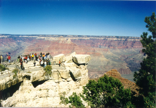
You can view the Grand
Canyon from several viewpoints along the road of the
rim, East Rim Drive. This road is 42km long and runs
from the Village to the furthest point, Desert View.
There are also some great viewpoints located along the
14.5km West Rim Drive. From the end of May to the start
of September these roads are closed to private vehicles
(due to the large number of visitors) but you can travel
between the view points by bus instead (for free). The
scenery you will see from these viewpoints is simply
amazing. From every viewpoint you will see slightly
different things – from some you will see the Colorado
River winding along the bottom of the canyon, while from
others you will only see seemingly endless cliffs. There
is no need to stop at every single viewpoint, however;
after a few you may find that even this gorgeous scenery
can get repetitive. If you are travelling with kids,
their patience will run out after a while.
A word of
caution: There is no fence (or only a low fence) at many
of the viewpoints so as to not ruin the natural scenery.
Don’t let your children get close to the edge. Keep them
at your side.
Besides the viewpoints, you can also
visit a town called Tusayan near the canyon, where there
is a small museum and an ancient Native American
village. Be sure to visit Desert View as well, where
there is an old Native American viewing tower. You can
climb to its top, look out at the view and in at the
interesting pictures on the building’s walls and
ceiling.
The park rangers organise a wide variety of
activities for visitors to the park all year round,
including in the evenings (indoors during the winter,
outdoors during the summer). You can get more
information about these activities in the visitor centre
and in the park newspaper, given out for free upon entry
to the park.
Unlike most other national parks in the
US where there are hiking trails of varying difficulty,
the trails of the Grand Canyon are all quite difficult
and recommended for experienced hikers only due to their
steepness. The only trail suitable for families and
casual hikers is the Rim Trail. There are also mule
tours from the rim of the canyon down to the bottom of
it. There tours aren’t recommended for children or
people who are not in top shape either.
Another
special and rather pricey option for seeing the canyon
is by flying over it in a small plane or a helicopter.
These flights leave daily from the small airport near
the park and from Las Vegas and Flagstaff airports. For
those who can afford it, this is an incredible
experience you will never forget.
More National Parks:
A trip to Yosemite National Park
Sequoia and Kings Canyon
Death Valley National Park
Lake Powell and
Antelope Canyon
Zion National Park
Everglades National Park