Travel in Hawaii, the Big Island
♦ Routes (free): Detailed travel itineraries in USA
General Overview:
The Big Island is the most surprising of the Hawaiian Islands. It is the most diverse of the islands both in terms of climate zones and in terms of landscapes and sites. In its western part, the sun shines throughout all days of the year, while its peaks are covered with snow in winter, so on the same day, you can ski in the mountains and then swim in the pleasant sea water. The island has green valleys with waterfalls, rain forests, deserts, active volcanoes, lava fields, and beaches of all types: rocky, with white, black, and even green sand! The coastline length is over 420 km. The island has many historical sites from the period of the first Polynesian settlers and the kings of Hawaii, and it is considered the "most Hawaiian" of the islands.
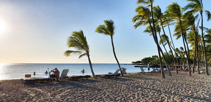
Waikoloa Beach in the northwest of the island:
Book guided tours on the Big Island from GetYourGuide.com:
Hawaii, known by its nickname "The Big Island," is indeed, quite surprisingly, the largest of the islands. Its area is about 10,000 sq km, almost twice the area of all the other Hawaiian islands combined, and it is important to note that it is still continuing to grow. This is the youngest island in the Hawaiian island chain, born "only" 800,000 years ago (compared to Kauai whose age is estimated at about 5 million years) and the southernmost of them all.
Book recommended tours on the Big Island from Viator
The island is composed of five volcanoes, two of which are still active: Mauna Loa and Kilauea. 42 years ago, Kilauea erupted for the first time, and fire fountains over 600 meters high burst from it. The next to last eruption in the eastern part of the mountain began in 1983, and since then lava flowed from it until the beginning of 2018.
In May 2018, a severe eruption occurred in the southeast of the island, many houses were burned, and roads were blocked. As of October 2019, lava was no longer observed flowing on the island. Volcanoes National Park has changed and certain hiking trails were canceled. Visitors to the place are recommended to go to the park's visitor center and get updates on the open hiking trails.
Further update: at the end of September 2021, another eruption began at Kilauea. Additional update: at the end of December, a short eruption occurred at the Kilauea volcano. Another eruption could occur at any time.
Some of the roads blocked during the volcanic eruption in 2018:

Mauna Kea, the highest mountain on the island, rising to a height of about 4,600 meters above sea level, is the highest mountain in the world when measured from the ocean floor. At the mountain's summit are the strongest telescopes in the world, providing astronomers with the best viewpoint in the world of the stars and other worlds. The mountains on the island have moderate slopes, unlike Kauai and Oahu which have steep and impressive cliffs. Due to the island's young age, the forces of nature (wind, water, erosion) have not yet had time to shape the terrain. Only in the Kohala Mountains area, which are the oldest on the island, did steep cliffs and narrow valleys manage to form.
Everywhere else in the world, when a volcano erupts, everyone flees as far as possible and seeks cover, but on the Big Island of Hawaii, the exact opposite happened: during a volcanic eruption, crowds of people arrived from all the other islands (and even from more distant places) to watch the flowing lava from as close a distance as possible. Unlike volcanoes such as Vesuvius in Italy or Mount St. Helens in Washington State, the volcanoes on the Big Island were not of the exploding type. On the Big Island, the lava emerged moderately from the earth's belly, flowed slowly down the mountain to the ocean, and it was possible to approach and watch the lava, what is sometimes called: "Drive-in Volcano." No wonder the island is also nicknamed: "Volcano Island." Volcanoes National Park is undoubtedly the most popular attraction on the island.
The island is unique in its structure and the amounts of cold lava covering it, and those traveling there feel like discoverers of worlds. This is the place where the earth's surface changes at the fastest rate in the world. In some areas on the island, you step on ground that is younger than the traveler's age! A unique experience, without any doubt.
The first astronauts who flew to the moon practiced on the island for their missions in the lava fields of Mauna Loa.
Another nickname for the island is the "Orchid Isle" because orchids thrive in its eastern part, replacing the sugar fields that were the main crop on the island in the past. More orchids grow in Hawaii than anywhere else in the world.
Other branches of agriculture are: coffee crops in Kona, macadamia nuts, papaya, fish, algae, and cattle ranches.
The number of inhabitants on the island is about 150,000, while their ethnic origin is very diverse, most of them live in Hilo and Kona.
The number of tourists on the island reaches 1,300,000 per year and it is on an upward trend. In recent years, more and more tourists are discovering the wonders of the island, which is consequently in a momentum of development and construction. However, due to its large size, it is still quiet, with many uninhabited areas, vast lava fields, and without congestion and traffic jams. Still, the primary source of income for the island's residents is still from agriculture and only in second place (as the gap narrows every year): tourism. This is likely the first island discovered and settled by the first Polynesian settlers as early as 500 AD.
Because the Big Island was the birthplace (in 1758) of King Kamehameha I, who united all the Hawaiian islands into one kingdom and his primary place of rule (this is the main reason why the state of Hawaii is named after this island), it has many historical sites and ruins of ancient temples, mainly along its western coast which served as the arena for the primary activity and entertainment of kings and queens in the ancient period.
Statue of King Kamehameha I:

Captain James Cook, the famous world explorer, was killed by the island's residents in Kealakekua Bay in the west of the island in 1779.
♥ Recommended Hotels on the Big Island:
In the West of the Island:
Recommended to stay in the Waikoloa area
Wonderful 4-star hotels:
Highly recommended:
Or:
♦ Waikoloa Beach Marriott Resort and Spa
Or:
♦ The Westin Hapuna Beach Resort
Cheaper, recommended suite hotel full of facilities and activities (not on the beachfront):
♦ Kings' Land by Hilton Grand Vacations Club
Even cheaper (and more distant from the sea):
3-star resort with 1-2 bedroom villas, abundant in sports facilities.
In the East of the Island
Hilo
♦ Grand Naniloa Hotel, a Doubletree by Hilton
4-star hotel, located in Hilo Bay, close to Hilo city center, includes family rooms and suites with a kitchenette, pool, and restaurant. Free Wi-Fi and parking.
4-star hotel, located in Hilo Bay, close to Hilo city center, includes family rooms, pool, and restaurant. Free Wi-Fi and parking.
Or: High-quality Bed and Breakfast:
Includes pool and jacuzzi, about two miles north of Hilo. Air conditioning, terrace and garden, grill, free private parking, free Wi-Fi.
The island can be divided into four main tourist areas:
Northeast of the Island
"Windward" side, which is the tropical and rainy side of the island including the capital city Hilo, which is the largest of the island's cities, and near it the international airport and also a port where cruise ships arrive.
The Hamakua region, in the northeast of the island between Hilo and Waipio Valley, is nicknamed "Valley of the Kings." The road ends at the entrance to Waipio Valley, which was once home to a Hawaiian native community. This is the largest valley on the island and can only be reached by off-road vehicles or by mule riding. The entire eastern part of the island is abundant in tropical vegetation, agricultural crops, and waterfalls and is known for its magnificent arches.
Recommended guided tours for cruise ship passengers from Hilo port:
(Includes pickup and return to the port)
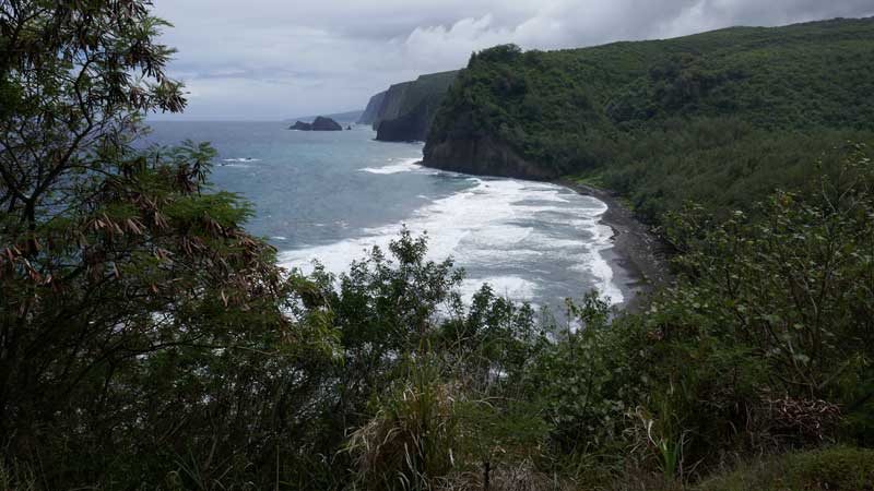
View of the northeast of the Big Island from the direction of Pololu Valley:
Kohala
Located in the northwest of the island. In South Kohala along a 32 km coast are the most luxurious and largest hotels on the island, adjacent to some of the most beautiful beaches in the world and vast golf courses. This area is known as the "Gold Coast" because of its wonderful sand or perhaps because only those with great wealth and gold can afford to stay in the luxurious resorts there.
The main port of the Big Island, KAWAIHAE BAY, is also located on the Kohala coast.
North Kohala is a mountainous and wild area with small and peaceful towns and is famous as the birthplace of King Kamehameha I. South of it is the WAIMEA area, known for its cattle ranches, the most famous of which is Parker Ranch, the largest private ranch in the world. Waimea is a cowboy town with rodeo events and Wild West attire.
Kona District in the West of the Island
This is the "Leeward" side, which is the dry, sunny side and includes Kailua-Kona, the most touristy city on the island, where most of the hotels, restaurants, shopping centers, and events are located, and the towns to its north and south. This is a true paradise for water sports enthusiasts: swimming, diving, sailing, fishing, and surfing. The hills above Kona are the growing place of the excellent KONA COFFEE. In the area are places of great historical importance such as: the place of Captain Cook's killing and the ancient Place of Refuge, HONAUNAU.
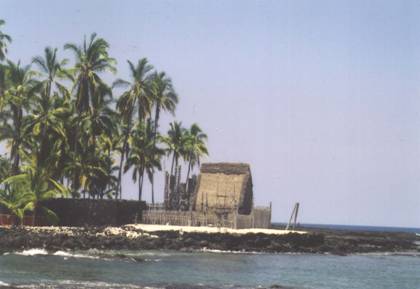 Historical Place of Refuge
South of the Island
In this area is the southernmost point in the USA, KA'U. Southwest of the island is an area swept by strong winds throughout all days of the year, with very few residents who earn their living mainly from growing oranges. The area is known for its unique beaches: with green sand and black sand and for the many sea turtles living in them. The main attraction on the island, the active volcanoes located in the "Volcanoes" National Park and the small towns adjacent to it are also located in the south of the island.
The Beaches:
On the Big Island, there are fewer sandy beaches than on the other islands in Hawaii. The reason for this is the relatively young age of the island. White sand is created in a slow process of coral and shell disintegration and is therefore more common on older islands (Parrotfish, common in the Pacific waters, disintegrate the corals. Each fish can produce three tons of white sand a year on its own). At the same time, the beaches that are on the island are considered the most beautiful in Hawaii, and even more so: in all of the USA. Also, the beaches on the island are unique and very diverse. Where else can you find beaches with white sand, gray sand, black sand, and even green sand? All this combined with excellent weather all year round. Because the island is still in a process of formation and its volcanoes are active, its beaches (mainly in its southern part) change. The most famous black beach in Hawaii (KAIMU BEACH) was completely covered a few years ago by a thick layer of lava. In other places on the island, the lava flowing to the sea disintegrates and is turned by the waves into new sand. The strong currents carry the new sand and deposit it in small bays and thus within a few months of the last eruption, new beaches are created.
Swimming beach with black sand - Punalu'u Beach

The most beautiful beaches on the island are located on its western, sunny side: clear turquoise water, particularly clean and quieter (usually) than in all other Hawaiian islands. The beaches, mainly in the Kona area, are a paradise for divers and snorkeling enthusiasts. The abundance of fish, in a variety of colors and species, eels, and sea turtles is amazing in its diversity.
Mauna Kea Beach - Kaunaʻoa (Mauna Kea) Beach

On the eastern, rainy coast, the beaches are stormier and grayer and therefore much less popular. All beaches in Hawaii are public, which means that anyone can visit and enter all beaches on the island for free. There are organized beaches with parking, a lifeguard, toilets, and showers and in contrast, hidden and exotic beaches, without any means, which can only be reached by off-road vehicle driving or walking on long trails. In many sea beaches, there are not enough shaded spots and therefore it is recommended to buy (or rent) an umbrella and arrive with it at every beach you visit. Other important equipment: a hat, sunglasses, sunscreen in large quantities (remember that the radiation intensity is extremely high due to proximity to the equator), a one-time underwater camera for photos of the fish and other sea creatures you will see in the water, fish food, mask, fins, and plenty of drink.
Google Map of the Big Island Hawaii:
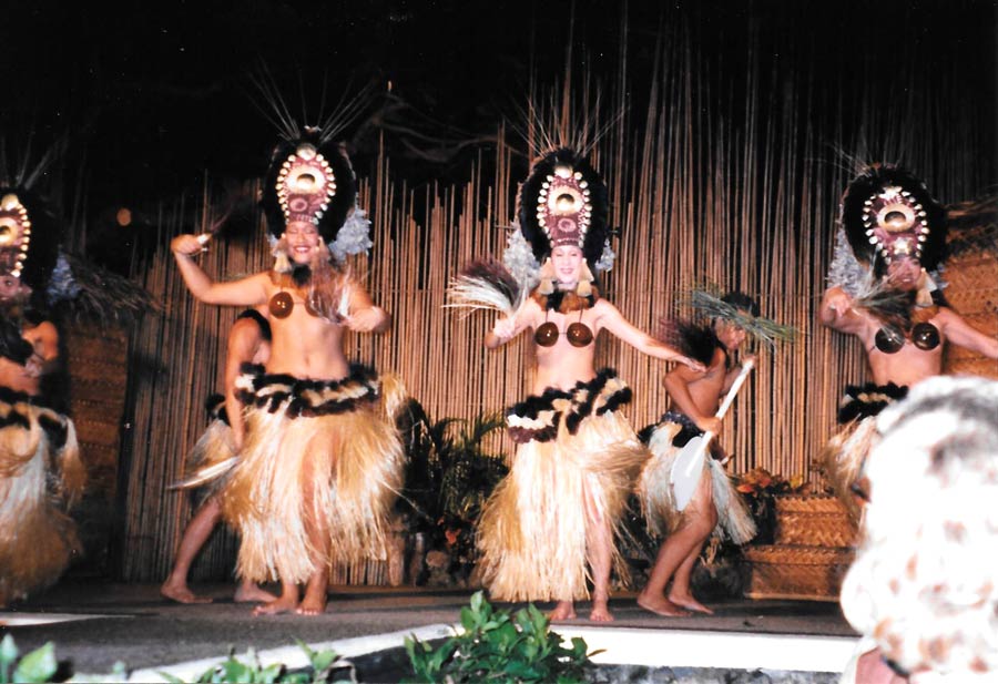
Traditional Hawaiian Show and Meal - LUAU
A visit to Hawaii is not complete without participating in a LUAU. This is an interesting performance including dinner, dances (including a fire dance) and typical local songs, various ceremonies and explanations on Hawaii's tradition and history. Each participant naturally receives a lei of flowers or shells.
Attractions in the South of the Island:
Hawaii Volcanoes National Park is one of the most unique and fascinating national parks in the entire USA and is considered the most popular attraction on the island.
Puu Oo volcanic crater on the Big Island (photographed on a helicopter flight: Dekel Bar, October 2019):

It is also the only park whose area is steadily growing. The park is located in the southeast of the island, about a two-and-a-half-hour drive from the city of Kona, and 45 minutes from Hilo, and entry to it is from highway number 11. The park is open 24 hours a day all days of the year. The place was declared a national park as early as 1916. Entry to the park is for a fee, but holders of an annual pass for the national parks in the USA are exempt from this payment.
One of the central attractions in the park is an active volcano named KILAUEA VOLCANO which was active continuously from January 1983 until the beginning of 2018. This is the most active volcano and has the longest eruption in the world. Another volcano located within the park grounds, which has not erupted for many years, is the mighty mountain, Mauna Loa.
Kilauea volcanic crater (photographed by: Dekel Bar, October 2019):

The lava flowing from Hawaii's volcanoes is hotter and less viscous than in other volcanoes and therefore its flow is easier and less violent. Thanks to this, it was possible to approach the area where the lava flowed, which allowed tens of thousands of people to stand face to face with the forces shaping the Earth. At the same time, it is important to remember the power of nature's elements and be careful of them; hundreds of houses have been destroyed since the next to last eruption of Kilauea and many more houses were burned in the eruption that occurred in 2018 and several roads were blocked both by lava and due to large cracks in the roads. The sights in the park are extremely diverse, ranging from desolate lava fields to green jungles rich in vegetation. The weather also changes from dry desert to rain forests. Temperatures in the park are significantly lower due to the height of the volcanoes and it is advisable to bring a light jacket.
Kilauea Iki crater:

It is recommended to start the park visit at the KILAUEA VISITOR CENTER located near the park's main entrance. In the center, open daily between 7:45-17:00, there is extensive information and displays on the park's flora and fauna, on previous volcanic eruptions in the area and on the condition of the hiking trails. It is worth obtaining (for free) maps and information on the park's hiking trails. In a small cinema, a fascinating movie is shown on the island's formation, the first volcanic eruptions in the area and the island's flora and fauna. Free tours led by park rangers depart from the visitor center.

Jagger Museum, located about 5 km from the visitor center, is a museum entirely dedicated to volcanic and seismological phenomena. It has several active seismographs and various interesting displays including movies on the volcanic eruptions in the park. Entry is free. The museum is open daily between 8:00-17:00. The view of the crater from the viewpoint adjacent to the museum is particularly impressive.
Note: Some of the following roads and hiking trails have changed following the eruption in 2018 - check at the park's visitor center which trails are open and recommended:
A road called "CRATER RIM DRIVE", about 18 km long, surrounds the central part of the park, and circles the large crater created by the volcano's eruption, KILAUEA CALDERA. Along the road are interesting viewpoints, some of which serve as starting points for hiking trails of all difficulty levels inside the crater or around it. A special experience is walking inside a desolate crater as steam vapors rise from cracks in the black ground surrounding you.
Recommended viewpoints are: HALEMAUMAU OVERLOOK from which the entire crater is well seen. STEAM VENTS, where you can stand near pits from which hot water vapors are released from the ground. The vapors are created due to rains that fell in the area and the water that seeped into the ground heated up by the underground lava streams. At a nearby point called: SULPHUR BANKS, you can see and especially smell the sulfur that was also released from the depths of the earth.
Video about a trip in Volcanoes Park on the Big Island including a flight over the park:
(Filmed by: Dekel and Meir Bar, October 2019)
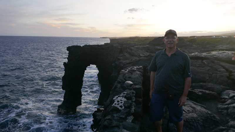
"CHAIN OF CRATERS ROAD" is a road about 30 km long departing from CRATER RIM DRIVE and reaching the point where the flowing lava blocked the road, near the ocean.
Lava arch in the water - Holei Sea Arch:
Along the way are cold lava fields of all types that flowed over vast areas. In every place, the period of years of the lava is indicated. The colors of the lava fields are diverse: ranging from black for lava from many decades ago, to silver and gold for lava a few years old.

Video about black sands, cliffs, and arches at the southeast beaches of the Big Island in Hawaii:
(Filmed by: Dekel and Meir Bar, October 2019)
The lava tube that was in the park was blocked in the eruption in 2018. You can visit another tube near Hilo called Kaumana Caves:

SOUTH POINT
In Hawaiian: KA LAE (meaning: "The Point") is the southernmost point on the island, which is the southernmost point in the entire USA (located at a latitude 800 km south of Miami). This is a windswept area with high cliffs and a stormy, wild sea. It is also the first place reached by the first Polynesian settlers who discovered Hawaii, but today the area is hardly inhabited. Near the southernmost point is the most unique sea beach on the island, the Green Beach (details in the chapter on the island's sea beaches). To reach SOUTH POINT, you must drive from Kona on highway number 11 south, and about 10 km west of the town of NA'ALEHU turn onto a road called: SOUTH POINT RD., drive on it for about 13 km, turn right at the "fork" and continue until the road ends.
On the way, you will pass a wind turbine farm that utilizes the strong winds in the area to produce energy.
