Trip to Fraser Island - K'gari
and Whale Watching
Fraser Island, or by its new indigenous name K'gari, located about 350 km north of Brisbane, is the largest sand island in the world, 123 km long and 22 km wide. Most of the dunes on the island are 100-200 meters above sea level, and the highest dune is 244 meters. Drill samples have shown that the depth of the sand reaches up to 100 meters below sea level. Most of the island is covered with different types of rainforests and eucalyptus forests. Scattered across the island are over a hundred crystal-clear freshwater lakes, and there are many streams with pure water originating from springs flowing from a massive water reservoir beneath the island.
The UN (UNESCO) declared it in 1992 as one of the world's natural treasures that must be preserved.
Arrival
From Brisbane, you can take a two-day guided tour including meals and an overnight stay on Fraser Island.
You can also arrive independently by car or by flight to the airport of the town near the island, Hervey Bay. You reach Fraser Island by ferry from Hervey Bay. On the island, you can only drive in 4X4 off-road vehicles.
It is recommended to buy tour packages on the island that include transportation departing from Hervey Bay or Brisbane. Another starting point for a trip to the island is "Rainbow Beach".
Book this tour departing from Brisbane or Hervey Bay or Whale watching (from the Viator website):
This article describes a three-day trip which includes:
- Whale watching cruise and the first night's stay in Hervey Bay.
- A two-day guided tour on Fraser Island for three people with a 4X4 bus, including accommodation and food on the island.
Day One: Drive to Hervey Bay and Whale Watching Cruise
Arrival in the city of Hervey Bay. This city serves as a starting point for ferries to Fraser Island and is also the most successful place to depart on whale watching cruises, as hundreds of whales gather off its coast during this season. Check into the hotel and continue to the city port. At one o'clock, depart for a whale watching cruise which lasts about four and a half hours on the largest ship in the port, named Hervey Bay Spirit.

There was a strong breeze during the cruise, and they say this is actually good because the whales jump more when there are waves; however, on the other hand, the ship might rock, but there were moderate waves and the ship was quite stable, and there were many whales surfacing, many pairs with a whale calf next to them. When the calf suckles, its mother stands vertically in the water with her tail poking out above the water. At the bottom of the ship, there were transparent windows for viewing underwater, but there was no need to look at them because the sight above the water was beautiful and fascinating enough.


After the cruise, dinner at an Irish restaurant named Hoolimins on the beach, which was recommended at the hotel. Although it was a large restaurant, it was lucky we found a free spot because it is very popular and was almost completely full. The food was indeed tasty and the atmosphere and design of the place were pleasant.
Day Two: Trip to forests and along the beach on Fraser Island
The ferry to Fraser Island departs from the "River Heads" port, located about a twenty-minute drive south of Hervey Bay. The transport (included in the trip) collects from the hotel to the ferry.


Depart for the island at 08:45 on a ferry that is also intended for vehicles and is essentially a landing craft with a large front door that opens and goes down onto the beach; it doesn't need a pier, and there wasn't one either.
Arrival at the island within about half an hour of sailing to a place called Wanggoolba Creek.
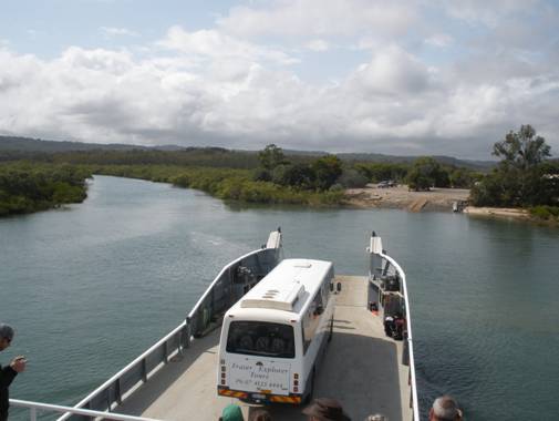
On the island, first all the 4X4 off-road vehicles (there are no paved roads on the island, only sand) got off, and after them all the passengers. Waiting for the travelers were several 4X4 buses. There are several tour packages for the island; some travel it for only one day, some for two days, like us, and a few come for three days. There are tours for small groups and for large ones of up to 40 people, and there are trips for young people up to age 35, backpackers, etc.
Our bus had about forty seats, but we were only 23 travelers of various ages from our twenties to our late fifties. There were travelers of Asian, German, French, and Australian origin, and we were the only Israelis. Our guide was excellent and explained constantly about the structure of the island, the flora and fauna, and its history.
He was also the driver, the guide on all the trips, and also took care of all the surrounding matters (food, accommodation, transport from the hotels and back to them).
Start with a drive to the Central Station in the center of the island on a sandy road deep in the forest.

The road is narrow and winding, almost the width of the bus, and yet the driver drives on it quite fast. Some of the roads on the island are one-way and some are two-way, but there is almost no difference in the width of the road! On the two-way road, if a vehicle comes from the opposite direction, the smaller vehicle must make way (occasionally there are trenches on the sides of the road that the yielding vehicle enters). All roads on the island are sandy as mentioned, and if it doesn't rain, the road becomes harder for small vehicles to pass because the wheels create a deep rut in the sand on the road, and in the middle, a sand hill rises, which small vehicles get stuck on with their undercarriage. Luckily for us, we came in a non-busy period and after some rain fell, so we never delayed because of vehicles that got stuck.
Get off the bus at Central Station, receive an explanation about the place that was a lumberjack camp in the past, and some of their housing still remains there. Today it serves as a station for the Rangers (park keepers) and as a starting point for hiking trails deep in the forest along Wanggoolba Creek.


Walk for about twenty minutes with the guide who explains about the place, the flora and fauna, and then continue alone for another forty minutes along the creek to the place where the bus is waiting.


From there drive to have lunch at the Eurong Beach resort restaurant, where we arrive at 11:30.
Three-quarters of an hour later we are already on the bus and moving fast north on the beach at a speed of about 80 km/h!

On the eastern coast of the island, there is a section that is tens of kilometers long, smooth, and almost obstacle-free, which serves as the fastest road on the island, and all regular traffic laws apply to it. The maximum permitted speed is 80 km/h, and there are places on it that also serve for the takeoff and landing of light aircraft. When we reached one such plane that was waiting on the beach, the guide asked who wanted to fly over the island with this plane (for fifteen minutes for a price of $70). Half the passengers, including us, wanted to fly, but there wasn't room for everyone on the plane, so the plane did it in two rounds. We went on the first flight.

At first, the plane circled over the sea and over the coastline so we could see turtles and sharks in the water. We saw something similar to a turtle and the very long coastline with all the vehicles on it; then the plane turned toward the center of the island and flew over the forests, the dunes, and the lakes. Part of the island was covered in heavy clouds and it rained there; we moved away from there and returned toward the beach. We flew over an old shipwreck called "Maheno" and landed next to it. The bus was waiting for us there too.
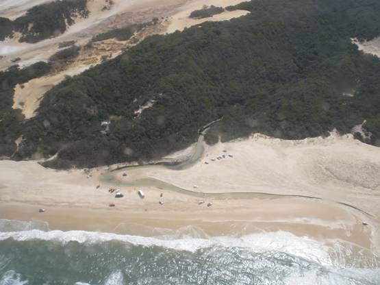


We continued north and saw on the way reddish-colored canyons that are attached to the beach. We stopped next to one of them called the Red Canyon (how not?).


On the way, on the beach, we also saw a dingo dog that was looking for something to eat. It is forbidden to feed these animals (which look like dogs but are actually a type of wolf) so that they don't get used to it and bother travelers. There are about one hundred and twenty dingos on the island, and when traveling with small children, you need to watch them because they are capable of attacking a small child, especially when they roam in groups.
Along the beach, there were many groups of fishermen who arrived with their off-road vehicles to the island, and some even had tents on the beach. Near the Red Canyon, we saw one who caught fish about forty centimeters long. He used a bait of a sardine fish to which he attached a series of four hooks.
From there we continued north to Indian Head, which is one of the few places on the island that is not made of sand. This is a 60-meter-high volcanic rocky cliff which constitutes a beautiful observation point over the beach and the sea. When the sea is calm, you can see sharks and stingrays from it. We hiked up to its summit, and on the way, light rain started to fall. On the way back, the trail was already slippery from the rain. On the bus, we changed shirts that were completely soaked.


We returned south and on the way, the guide stopped in a place where there were tiny bumps on the beach. He dug with his hand to a depth of about five centimeters and pulled out a shell closed on both its sides. He pointed at more bumps on the beach and everyone started collecting shells. The guide said that the natives of the place, the Aborigines, used to collect them for food, and today's fishermen sometimes use them as bait for fishing. To us, he said to wash them in water and set them in a line to have a race! We put them in a line on the sand and waited. After a minute or two, we suddenly saw the shells turning and diving into the sand and disappearing.


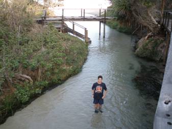
We left the shells to their own devices, continued south, and stopped at Eli Creek. This is a creek that has a raised wooden path along it, and you can also walk inside it in its shallow and clear water (and there are also restrooms there, that's also important).

From there we returned to the Eurong Resort, where we arrived at 17:00, checked in, were also on the internet (expensive), and after a shower, we went to eat a good Mediterranean-style dinner. After the meal, we played snooker and then went to sleep quite early.
Day Three:
Amazing dunes and clear water lakes
Set off on the bus at 08:30 after breakfast at the hotel. Drive on the beach north to a point on the beach from which you walk for about half an hour on foot on the northern path of the two paths that lead to Lake Wabby. The beginning of the path is in the vegetation, and its end is at a giant dune attached to the lake.


The lake water is green, very clear, so you can see the fish swimming in it (including quite large fish). We saw catfish about thirty cm long near the shoreline.


The sand dune ends steeply right next to the lake, and a special experience was rolling quickly down the steep slope into the water.
We entered the fairly cold water (21-22 degrees Celsius) and swam a little; most of the time it was sunny, and the temperature outside was about twenty-five degrees. The sand is really soft and pleasant, and it was fun to also dig in it.


Return to the beach on the southern path, which is longer, about three-quarters of an hour walk in the forest, where the driver is waiting to take us to the hotel to eat lunch.
After the meal, drive in the forest for about half an hour to Lake McKenzie on a road that is quite bumpy and bouncy. Near the parking lot, we saw a large colorful lizard about seventy centimeters long.


The guide told us we have two hours to spend alone at the lake. This is a large and clear lake with turquoise water and fine, white sand on its shore. We entered the water and lounged on the beach; we also dug a hole in the sand near the water, and to our surprise, the hole filled with very murky water, in complete contrast to the clear lake water.


At 15:20, the guide gathered everyone, and after a drive of about half an hour, we reached the place where we got on the ferry at 16:15. Upon getting off the ferry, the vehicles were waiting to take the travelers back, each to their hotel or to the airport.