A trip to Sequoia and Kings National Parks
Sequoia and Kings Canyon are two beautiful neighbouring
national parks, often visited together. Sequoia is the
southern of the two parks. The two of them together are
3416 square kilometres.
Sequoia is the second oldest
national park in the US, after Yellowstone. It was
declared a national park in 1890 in order to protect the
enormous sequoia trees growing in it, including General
Sherman Tree, the biggest tree in the world. Sequoia is
also home to the tallest mountains in the US (outside of
Alaska): Mt. Whitney and Mineral King. Kings Canyon was
declared a national park only in 1940.
Besides the
forest of enormous trees the park has caves, rivers,
lakes and waterfalls. Over a million and a half people
visit the park every year, with most of the visitors
coming in the summer months. The park is open every day
of the year, but two areas of it are closed during the
winter: The road to Mineral King (in the south of
Sequoia) is only open from mid-May to the start of
November (if the weather allows for it to open), and the
road to Cedar Grove (in Kings Canyon) open from
mid-April to the start of November. The park has over
220km of roads and 1280km of hiking trails! Entry costs
$10 per private vehicle for one week. The optimal length
for a family visit to the park is two days. Any longer
and you’ll start to hear complaints such as “We’ve
already seen enough trees...” from your kids, even at
the sight of one of the largest trees in the world.
Park Location and Transportation
The park is in east
California. It sprawls from San Joaquin Valley to the
Sierra Nevada mountain range. Sequoia and kings Canyon
are halfway between Los Angeles and San Francisco (and a
little bit east), five hours away from each. The
airports nearest to the park are Visalia airport, 58km
west of Sequoia, and Fresno airport, 85km west of Kings
Canyon.
Two highways provide access to the parks.
Highway 180 enters Kings Canyon National Park from the
northwest via Fresno, and Highway 198 enters Sequoia
National Park from the southwest via Three Rivers.
Highway 180 provides the access to the farthest eastern
vehicle-accessible point near Cedar Grove. There are no
roads in the parks that cross to the east side of the
Sierra Nevada. Additionally, there are no roads to enter
the parks from the east (highway 395). The two parks are
connected by a road called Generals Highway, a beautiful
road 74km long which connects to highways 180 and 198 at
its ends.
Weather
The enormous differences in
altitude in the park – from 460 metres to 4800 metres
above sea level – lead to great differences in
temperature and weather conditions throughout the park.
Because of this you should be prepared for any sort of
weather and dress up in layers of clothing (easily taken
off or put on). Summer days are warm and temperatures
can reach 38 degrees Celsius in lower altitude areas.
The temperature at night is pleasant, around 20 degrees
Celsius. In higher altitude areas (though not at the
mountaintops) temperatures are around 24 degrees during
the day and 10 degrees at night.
The weather during
spring and autumn is quite pleasant: Temperatures are
anywhere between 11 to 26 degrees during the day
(depending on altitude) and 0 to 11 degrees at night.
Winters are rainy and snowy but the temperatures are
fairly decent: 5 to 17 degrees during the day and -4 to
2 degrees at night.
Things to See and Do
The park
has several visitor centres. I recommend visiting one of
them upon entering the park to receive maps and
information and see the interesting exhibits they have
on display. Foothills Visitor Centre is located near the
town of Three Rivers next to highway 198, close to the
entrance to Mt. Ash. This visitor centre is open every
day of the year. The visitor centre in Grant Grove is
also open all year round. Other visitor centres are
located in Lodgepole, Cedar Grove and Mineral King and
are open only from May to September.
The main
attraction of Sequoia National Park is, of course, the
giant sequoia trees. Several areas of the park have
especially large numbers of these trees. The most famous
and unique trees in the park have names, and can be
reached by short and easy footpaths. Other footpaths
will take you between beautiful wildflowers and
waterfalls.
The best hiking trails, by area:
Giant Forest:
General Sherman Tree: A very short trail
leads to the biggest tree in the world, named after a
general from the US civil war. It is 83 metres tall and
31.3 metres in circumference. It is 3.2km north of Giant
Forest Village (where one of Sequoia’s hotels is).
Congress Trail: A round trail 3.2km long in the heart of
a sequoia forest. The trail starts next to General
Sherman Tree. It is highly recommended to anyone
visiting the park for the first time. Its main
attractions are the House and Senate Groups, the
President Tree and McKinley Tree. Give yourselves one to
two hours to tour this trail.
Trail for All People:
This is a paved trail suitable for anyone, including disabled people. It is one kilometre long and circles a meadow called Round Meadow. In the summer, beautiful wildflowers are at the height of their bloom there. At the sides of the trail you will find written information about wildlife in the forest and the meadow.
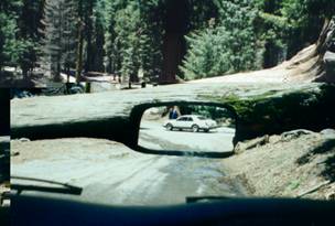
Moro Rock / Crescent Meadow Road:
This dead-end road starts at Giant Forest Village and heads 5km southwest. Along the road are a number of attractions. One is the Auto Log, a giant fallen sequoia tree on which you can drive your car. Another is Moro Rock, a large granite rock from which you can see a great view of the west side of the park. To get to its top you will have to climb 400 steep stairs, however, so it is not recommended for families with young children. Further along the road you will drive through a tunnel dug into the side of another fallen sequoia tree. The road ends at Crescent Meadow, which you can traverse on foot. In the winter this area is a nice place for playing in the snow and skiing.
Mineral King:
This area is in the south of Sequoia national park and is the highest altitude area you can reach in this park. It opens to visitors only at the end of May. The road to Mineral Kind is steep and winding, so drive carefully! You will arrive at a beautiful valley with many hiking trails, most of them quite long and recommended for people in good physical shape. The area has a variety of interesting rocks of different kinds, including granite and marble. If you are only visiting the park for one day, I recommend skipping this area as the drive alone takes an hour and a half each way.
Crystal Cave:
An 800 metre trail through a gorgeous canyon leads to a marble cave full of stalactites and stalagmites. Highly recommended! The cave is located between Ash Mountain and the Giant Forest near the Generals Highway. A guided tour of the cave starts at the entrance to spiderweb-like gate of the cave and takes 45 minutes. The temperature inside the cave is 9 degrees Celsius all year round. Bring along a sweater or jacket. The cave is open to visitors from mid-May to September, from 11AM to 4PM. Tickets can’t be purchased at the cave – they must be purchased at one of Sequoia’s visitor centres.
Grant Grove:
General Grant: This is the third largest tree in the
world. It was declared to be the US’s national Christmas
tree. A 500 metre hiking trail leads up to it. On the
way to it you will pass a historic little house, other
giant trees and a huge hollow tree trunk which you can
enter. The tree is 1.6km northwest of the visitor
centre.
Panoramic Point: An excellent viewpoint of
the Sierra Nevada from the north side of Kings Canyon.
Hume Lake: A picturesque lake in Kings Canyon 19km north
of Grant Grove. In the summer months you can swim, sail
and fish in its waters. You can rent a boat at Hume Lake
Christian Camps.
Cedar Grove:
This is the bottom
of Kings Canyon, where there are tall granite walls, a
roaring river and many waterfalls. It is often called
‘Yosemite’s competitor’, and it truly is. Its most
interesting points:
Canyon View: A beautiful,
U-shaped viewpoint of Kings Canyon. This viewpoint is
1.6km east of Cedar Grove Village.
Roaring river Falls:
A five-minute walk will take you to a roaring waterfall erupting from a crack in the granite rock. It is located 4.8km east of the Village. Highly recommended!
Motor Nature Trail:
A 4.8km one-way dirt road, suitable for private vehicles, which passes through a forest by the river. An excellent opportunity to spot small wild animals while driving.
More information: https://www.national-park.com/welcome-to-sequoia-kings-canyon-national-parks/
More National Parks:
A trip to Yosemite National Park
Travel to The Grand Canyon
Death Valley National Park
Lake Powell and
Antelope Canyon
Zion National Park
Everglades National Park